The Virtual Geoscience Revolution: Beyond Lidar – the democratization of Virtual Outcrops
Contents
The Virtual Geoscience Revolution: Beyond Lidar – the democratization of Virtual Outcrops
Stage 4 - Beyond basic LIDAR
Helimap, a Swiss company, borrowed an inertial navigation system from a Cruise Missile and developed a method of mounting the LIDAR scanner into a helicopter [VS04]. The creation of heli-lidar increased the practical size of virtual outcrops from less than 1km to 10’s of kms. Suddenly, huge datasets could be collected from seismic-scale outcrop sections such as the Book Cliffs in Utah, the Karoo in South Africa and large arctic outcrops in Greenland and Svalbard [BVBW08]. A second advance that occurred in 2006 was the co-registration of hyper-spectral imagery of the cliff sections. Using long range infrared sensors, similar to those used for satellite remote sensing (1100 – 2500 nm), it was possible to automatically map lithology and mineralogy from cliff sections and drape classified images directly onto the virtual outcrop [KBH12]. These advances, and the large datasets that were collected, required software to visualise and interpret the data. While some existing software was modified to handle the 3D data, the key step came when two software packages were developed in parallel, VRGS at the University of Manchester [HSHB15] and LIME at Uni Research in Bergen [BRN+19]. Both packages were specifically designed to deal with virtual outcrop data with a suite of interpretation tools, and they ran well on standard desktop PCs or even laptops. Virtual Outcrops had arrived!
Stage 5 – Drones and Photogrammetry: The democratisation of virtual outcrops
By 2010 a number of different groups were collecting, processing and using virtual outcrops. However due to the cost of the hardware (a typical LIDAR was in excess of £100,000) and the time-consuming nature of acquisition and processing, it remained a specialist tool. This changed with the advent of two parallel but unrelated advances. The first of these was the resurgence of photogrammetry and the release of a new set of algorithms called Structure from Motion (SfM). Photogrammetry is the concept of picking corresponding points on a series of pictures of an object, taken from different locations, and using this to reconstruct the scene in 3D. While the concept has been around for almost as long as photographs, it wasn’t until the advent of SfM in the mid 2000’s, coupled with advances in computer processing power, that it became a practical method for building large 3D models of outcrops.
The advent of SfM also coincided with the emergence of cheap consumer UAVs (drones), with high quality cameras that could take hundreds of photos of outcrops from optimal angles. Drones, combined with SfM, meant that suddenly anyone could build 3D virtual outcrops – and they did. By 2018, virtual outcrops had become commonplace and almost anyone working on outcrop geology was collecting and utilising them. A drone has become a standard piece of field kit and data from a 20-minute flight are processed in a few hours to produce an accurate, 3D photorealistic model of a cliff section of interest, that can be interpreted on a laptop. For the first time in 200 years, we are no longer reliant on recording geological information on 2D maps using coloured pencils. The Virtual Geoscience Revolution has arrived.
The Future
Virtual Geoscience is in its early days; as more people adopt the technologies, significant advances will come. During the 2020/21 Covid-19 pandemic, Virtual Field Trips based upon virtual outcrops became a key part of geoscience teaching. Virtual Reality (VR) (Figure 4A), Machine Learning and automated interpretation using Artificial Intelligent systems on vast datasets (Big Data) are coming. V3Geo.com, the first public cloud-based repository specifically developed for virtual outcrops, was launched in 2020, and more are coming. Virtual outcrop technologies are fundamentally changing how we do field geology; the future (Figure 4B) is once again very exciting!
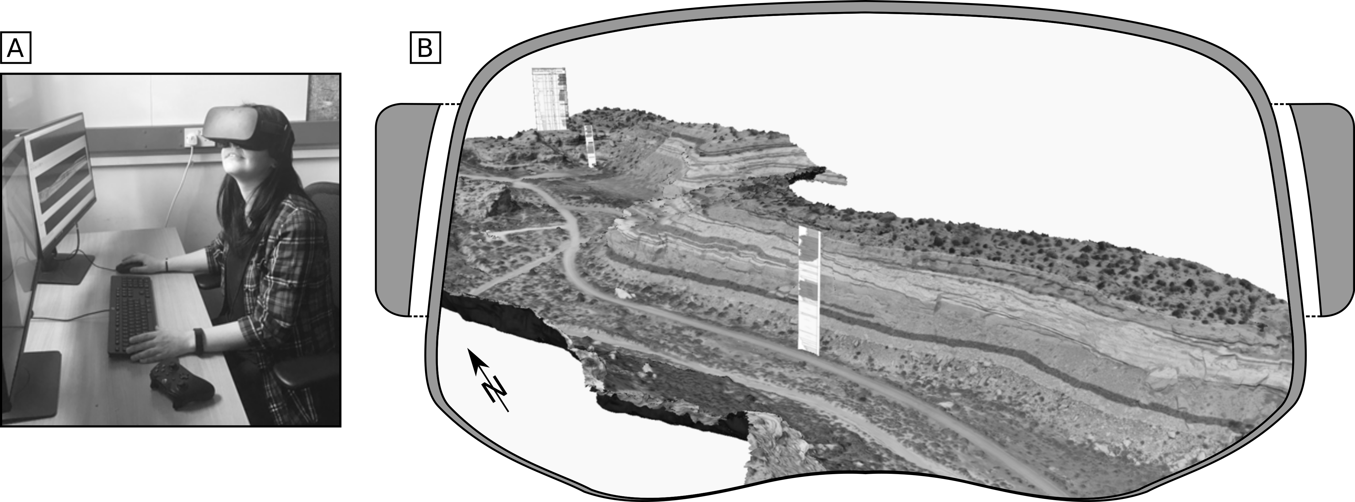
Fig. 4 Virtual Reality of outcrop models. A. Geologist using a VR headset to view a virtual outcrop in an immersive 3D environment. B. Approximate user’s view of a virtual outcrop in VR.
References
- BVBW08
Simon Buckley, Julien Vallet, Alvar Braathen, and Walter Wheeler. Oblique helicopter-based laser scanningfor digital terrain modelling and visualisation of geological outcrops. In The International Archives of the Photogrammetry, Remote Sensing and Spatial Information Sciences, volume XXXVII of B4. 2008.
- BRN+19
Simon J. Buckley, Kari Ringdal, Nicole Naumann, Benjamin Dolva, Tobias H. Kurz, John A. Howell, and Thomas J.B. Dewez. Lime: software for 3-D visualization, interpretation, and communication of virtual geoscience models. Geosphere, 15(1):222–235, jan 10 2019. URL: http://dx.doi.org/10.1130/GES02002.1, doi:10.1130/ges02002.1.
- HSHB15
D. Hodgetts, T. Seers, W. Head, and B.S. Burnham. High Performance Visualisation of Multiscale Geological Outcrop Data in Single Software Environment. In 77th EAGE Conference and Exhibition 2015. EAGE Publications BV, jun 1 2015. URL: http://dx.doi.org/10.3997/2214-4609.201412862, doi:10.3997/2214-4609.201412862.
- KBH12
Tobias H. Kurz, Simon J. Buckley, and John A. Howell. Close-range hyperspectral imaging for geological field studies: workflow and methods. International Journal of Remote Sensing, 34(5):1798–1822, nov 2 2012. URL: http://dx.doi.org/10.1080/01431161.2012.727039, doi:10.1080/01431161.2012.727039.
- VS04
Julien Vallet and Jan Skaloud. Development and experiences with a fully-digital handheld mapping system operated from a helicopter. In The International Archives of the Photogrammetry, Remote Sensing and Spatial Information Sciences, volume XX. 7 2004.